


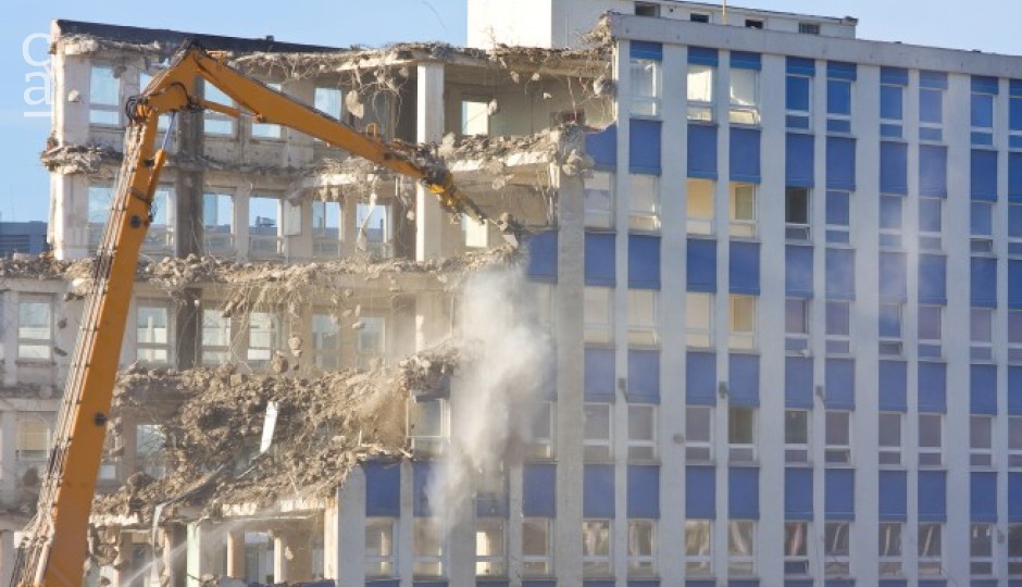
The recent and sudden demolition exercises in some cities in Nigeria, has sparked global outrage and has left in its trail sorrows, distrust, betrayals and trauma. This has become a frequent trend, without any clear justification or proof of evidence of advance notice from the government to the building owners before these exercises are carried out. It has also heightened tensions, as there are allegations of ethnic and political undertones to some of the demolitions. It is also disheartening that government watched her citizens build these structures to completion before unleashing their bulldozers to bring them to rubles when they could have stopped them at the foundation stages to minimize losses arising from urban corrective actions, if there is actually sincerity of such purpose.

These sudden demolitions has become painful pattern. One may argue that some developers erect buildings in wetlands, floodplains, and green belts, however, how governments notice only when the structures are fully built with response in drastic demolitions that devastate families, businesses, and communities calls for concerns, as it does not have to be this way. Again, the loss is not just to the affected individuals as the dollar denominated components of the demolished buildings continue to deplete the nation’s foreign reserve and further weaken the naira.
With the right use of modern technology, urban authorities can monitor land use in real-time, detect zoning violations early, and prevent unplanned development long before it turns into a crisis.

1. Drones for Aerial Surveillance
Drones can be deployed to capture high-resolution aerial imagery of fast-developing neighborhoods. Unlike traditional patrols, drones cover wide areas quickly, providing planners with up-to-date views of where new construction is happening. AI-powered image analysis can then flag new foundations or rooftops, alerting authorities before illegal projects become entrenched.
2. Satellite Imagery and Google Earth
Satellite imagery has become increasingly accessible, with platforms like Google Earth providing historical layers of urban growth. More advanced services (e.g., Planet Labs, Maxar) even offer near-daily updates. Urban authorities can overlay zoning maps on these images to track whether developers are encroaching into wetlands, buffer zones, or protected green spaces.
This means enforcement officers no longer need to wait for citizen complaints or tip-offs — they can see violations unfolding in near real time.
3. Geographic Information Systems (GIS) and Digital Mapping
At the heart of modern urban monitoring is GIS mapping. By creating a digital cadastre (parcel-by-parcel land registry) and overlaying it with zoning regulations, building permits, and environmental protection boundaries, authorities can instantly verify whether a new structure is legal.
GIS dashboards can also show hotspots of rapid development, helping planners focus surveillance resources where risks are highest.
4. GPS-Enabled Permitting and QR Codes
A common challenge is that many developers bypass the approval process. To fix this, urban authorities can implement GPS-enabled e-permitting systems. Every approved building permit would be geo-tagged and linked to a specific parcel. Developers would then display a QR code at the construction site — anyone, including citizens and inspectors, could scan the code to confirm if the structure is legal.
This level of transparency discourages illegal construction and reduces corruption in permit approvals.
5. Citizen Engagement via Mobile Apps
Technology should not stop at the government’s desk. With mobile apps or even WhatsApp bots, citizens can upload photos of suspicious construction and share GPS coordinates. This crowdsourced reporting creates a network of “community eyes” that supplements official surveillance efforts.

6. Benefits of Proactive Technology Use
- Fewer demolitions: Illegal structures are stopped at the foundation stage, avoiding humanitarian crises.
- Cost savings: Prevention is far cheaper than demolition, compensation battles, and legal disputes.
- Greener cities: Wetlands, floodplains, and green belts are preserved, improving climate resilience.
- Investor confidence: Clear, transparent monitoring reassures investors that property rights are secure.
- Global reputation: Cities that adopt smart monitoring are seen as forward-thinking, aligning with UN SDG 11: Sustainable Cities and Communities.

Barring ethnically or politically biased demolition exercises as largely being alleged as the reason for some frequent demolitions is some cities, The future of urban governance is smart, data-driven, and preventive. Instead of waiting until bulldozers are the only solution, cities can use drones, satellites, GIS, GPS-based permits, and citizen reporting tools to stay ahead of illegal construction.
In doing so, they will not only avoid the painful cycle of sudden demolitions but also build greener, safer, and more livable cities for everyone.
